GEOMORPHOLOGY AND HAZARD MANAGEMENT
Geomorphology helps us map and manage natural hazards.
0
54
Geomorphology and Hazard Management
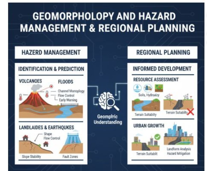
- Dangers are things that happen, whether they are natural or caused by people, that are too dangerous or come as a surprise. Chorley says that a geomorphic danger is "any change, natural or man-made, that may affect the geomorphic stability of a landform in a way that places living things at risk.
- As the earth moves, faults, folding, warping, rising, and falling can happen over time. These risks can also come from changes in the plant growth and hydrologic system caused by climate change. Risks that happen more quickly and directly include earthquakes, landslides, avalanches, floods, and volcanic events.
- Knowing about geomorphology can help you find and predict these kinds of dangers, as well as figure out how to handle them properly.
- We regularly record seismic events and earth tremors using seismic methods. We also regularly record the ground's surface, mostly by using tilt metres.
- We keep an eye on the temperature of crater lakes, hot springs, geysers, and fumaroles, as well as the gases that come out of these places. Lasers are used to track changes in the shape of dormant or extinct volcanoes, and we measure local gravity and magnetic fields and their trends.
- An in-depth study of the terrain and the location of possible explosion sites can help predict the direction of the lava flow more accurately.
- It is important to know about the geomorphic features of a river system and how it flows.
- Controlling river floods may be possible by studying things like channel shape, channel morphology, and pattern, as well as river metamorphosis, bank morphology, and more.
- These include these steps:
- To keep the water from heavy rain from going back into the rivers for longer.
- To speed up the flow of water (by smoothing out the winding pathways).
- To change the direction of water flow (through diversion routes).
- One way to lessen the damage storms cause is to build protected embankments.
- To let people know when floods are going to happen.
- If you don't know how erosion works in the upper catchment area and how much sediment the river carries, building levees to keep the flood water in the valley could be disastrous.
- For example, if the rate of erosion is very high in the upper catchment area, causing a high sediment load, there will be more sedimentation in the valley, which will cause the river bed to slowly rise, which could cause sudden flash floods whenever the levee is breached.
- It's possible for earthquakes to happen naturally or because of people.
- To find places that are weaker and more likely to have earthquakes, it is important to know how stable the land is and how buildings like dams and lakes can change the stability of the rock.
- In the same way, studying the geomorphic structure of hill slopes and the rock types that form them helps us figure out how stable or unstable the slopes are. With this information, it would be easier to find and map unsteady hill slopes that aren't good for building homes or roads.
Geology and planning for the region
- Geomorphology can be used in planning for regions. For a country's economy to grow in a balanced way, each area needs to have a clear idea of what it has to offer in terms of natural and human resources.
- Smart regional planners will be interested in detailed information on geography, soils, hydrology, lithology, and terrain features. This way, they can come up with the best growth plans for the area.