FLOOD DISASTER MANAGEMENT PLANNING
Understand the importance of planning for flood disasters, including risk assessment, emergency response, and mitigation measures.
Geology's Essential Role in Flood Disaster Management Planning
Geology's Impact on Flood Disaster Management
- Geology offers important insights into the fundamental causes of flood risk, allowing more precise forecasts and well-informed choices.
- Geology can help with flood catastrophe management planning in the following five ways:
- Recognizing flood-prone areas: Geologists can pinpoint locations that are at risk of flooding because of low-lying terrain, close proximity to water bodies, or historical flood episodes by examining the geological history and landscape morphology.
- Delineating flood danger zones and guiding land-use planning decisions are made easier with the use of this information.
- Evaluating soil properties: Soil permeability and infiltration have a big influence on flood risk.
- In order to ascertain whether water tends to pool on the surface or seep into the ground more rapidly, geologists can assess the properties of the soil. Designing effective flood control measures and comprehending how urban growth may change flood hazards are made easier with the use of this knowledge.
- Examining the dynamics of rivers and streams In order to determine if rivers and streams can withstand higher water volumes during flood occurrences, geologists examine the structure, flow, and behavior of these water features.
- This information is useful for planning flood control projects, such as levees and detention basins, and for determining the best locations for these types of projects.
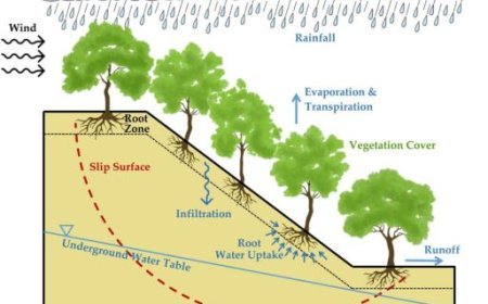
- Assessing the stability of slopes: By obstructing rivers or discharging material into streams, landslides and erosion can increase the danger of flooding. Geologists evaluate a slope's stability to pinpoint regions that are vulnerable to erosion and landslides.
- This information helps them decide on the best mitigation techniques, including better drainage or plant control.
- Geologists map out regions that are vulnerable to certain types of geological hazards, such as floods, in great detail. These maps are essential resources for directing disaster response activities, educating the public about flood dangers, and influencing land-use decisions.
Geological Applications for Reducing Flood Risk
- Having a better understanding of the geological components of flood risk can help develop more efficient flood control plans.
- Here are a few instances of how geology helps to lessen the effects of flooding:
- Land-use planning: Planners can avoid constructing in high-risk zones or take steps to mitigate flood hazards, such as floodplain restoration projects or legislation requiring raised building construction, by identifying flood-prone locations and taking soil characteristics into consideration.
- Flood control structures: Geologists are involved in the planning and placement of flood control structures, such as levees, dams, and detention basins, to make sure they function well and don't put the surrounding region in more danger.
- Early warning systems: By knowing a region's geology, more precise flood prediction models can be created.
- These models may then be used to influence the construction of early warning systems and notify communities of impending flood dangers.
- Recovery after a flood: Geologists can evaluate the geological effects of floods, such as landslides, erosion, or modifications to river courses, to help plan long-term flood risk reduction initiatives and post-flood recovery initiatives.
What's Your Reaction?


