GEOMORPHOLOGY AND ENGINEERING WORKS
Geomorphology assesses Earth's form, minimizing risks for safe and sustainable engineering projects.
Geomorphology and Engineering Works
- Most engineering work involves figuring out some kind of geologic factor.
- The most common type of geologic factor is the shape of the land.
Road construction
- The landforms in the area would be the best way to figure out the best traffic lines.
- Among other things, it is important for road engineers to know about the area's geomorphic past, the strength of the top layers, and the rocks' lithological and sedimentary features.
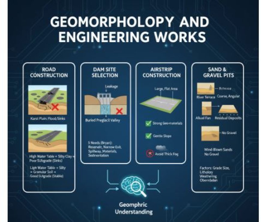
- A path through a karst plain needs to be cut and filled many times, or the road will flood when it rains a lot because sinkholes will fill up with water from the surface.
- In order to prevent the large solutional holes that are likely to be present from weakening the abutments when building a bridge in a karst area.
- There are many kinds of engineering problems that come up in glacial areas.
- A flat plain is the best place for building a road, but cut-and-fill is needed to avoid winding paths where there are end-moraines, eskers, kames, or drumlins. Roads that will see a lot of traffic are not good for mucky areas, which are where lakes once were.
- Heavy traffic will make the plastic materials under the lake floor flow if a road is made across them as they are. This will cause "sinks" in the roadbed.
- To avoid this, the lacustrine fill might need to be dug out and replaced with something that won't move when it's loaded down.
- Places with a lot of slope, like those in late childhood and early adulthood, will need a lot of bridge building, cuts, and fills. Landslides, earth flows, and slumping are big problems in these places.
- More and more, the subgrade, or the type of dirt below the road surface, is important for highway buildings that will handle a lot of traffic because it affects how water drains below the highway.
- When there are light loads on a highway, two factors primarily determine its lifespan: the calibre of the aggregate used to build it and the texture and drainage of the earth below it.
- Because of this, understanding how soils react to different types of topography and parent material is important for building modern highways. It is important to understand soil profiles, which show how geomorphic factors and events have affected the land.
- Subgrades of silty clay with a high water table don't work well for highways. Materials that are grainy and have a low water table work best.
Dam Site Selection
- Putting together what we know about the geomorphology, lithology, and natural structure of landscapes would make choosing places to build dams a lot easier.
- Kirk Bryan says that the five main needs for good reservoir sites rely on geology.
- A large enough bowl that doesn't leak water.
- A narrow exit of the pond with a base that will make building a dam cost-effective.
chance to build a satisfactory and secure channel to move extra water. - The ability to get the materials needed to build a dam (this is especially important for clay dams).
- Reassurance that the pond won't lose its usefulness too quickly because of too much mud and silt building up in it.
- Having limestone ground, for example, might make it hard to build a wall.
- Differential solutions can make the ground surface uneven, and if we don't have a clear picture of what's below, it could cost us money that we don't need to spend.
- Building in a valley is better because of the size of the dam that needs to be built, but it isn't always a good place for the dam.
- In glaciated places with buried bedrock valleys filled with sand and gravel, the terrain on the surface may not accurately reflect what's going on below.
- A dam could be put in a narrow spot in a valley, between a valley wall and a branch end.
- This would be the most basic level. But it's possible that the terrain below isn't right; there could be a hidden preglacial valley with sand and grit in it. If the dam was built there, it would leak.
Building Air Strips
- Engineers need to be able to choose good places for airstrips so planes can land and take off, and a geomorphologist's knowledge of the land's features could be very helpful to the engineer.
- The best places for airstrips would have a large, flat area with strong geo-materials nearby. This is where a safe and ideal runway can be built.
- Also, the ground should have a slope that is almost level, there shouldn't be any flooding in the area, and it should be easy to see, maybe even without regular and thick fog.
- A structural map of the area where the airport is going to be built could show these features.
Locating Sand and Gravel Pits
- Sand and gravel are used in many building, business, and manufacturing ways.
- To find good places for sand and gravel pits, geologists will have to look at things like grade size variation, lithologic makeup, degree of weathering, amount of overburden, and consistency of the deposits. You can find sand and gravel in a riverbank, a river terrace, an alluvial fan and cone, talus, wind-blown, residual, or glacier deposit.
- All of them have unique topographic links and forms, as well as different natural traits and growth potentials.
- Figuring out what kind of deposit it is is important for figuring out how valuable it might be.
- It is important to know the amounts of different grade sizes because gravel is usually in higher demand than sand.
- This is especially true now that clay isn't being used as much in home building.
- It is possible that floodplain layers will have a lot of silt and sand in them, and they will have a lot of different types of slopes both horizontally and vertically.
- Alluvial fan and cone gravels have sharp edges and vary in size, especially near the tips of their shapes.
- Aside from being sharp, talus materials are also too big for most uses and can only be used in certain areas.
- Wind-blown sands may be good for getting sand, but they don't have any rocks in them.
- There isn't a lot of variety in the residual layers, and the rocks that are found there are probably too worn down to be used as aggregate in cement work.
- When iron-coated chert is used as gravel in large amounts, it usually makes things worse. It's also expected that the residual layers will not be very large.
- Valley trains with terraces and outwash plains are good places for pits because they don't have a thick layer of rock on top of them and are usually quite large.
What's Your Reaction?


