EPEIROGENY
Epeirogeny: Earth's crust undergoes broad, slow uplifts or sinkings, shaping continents and ocean basins.
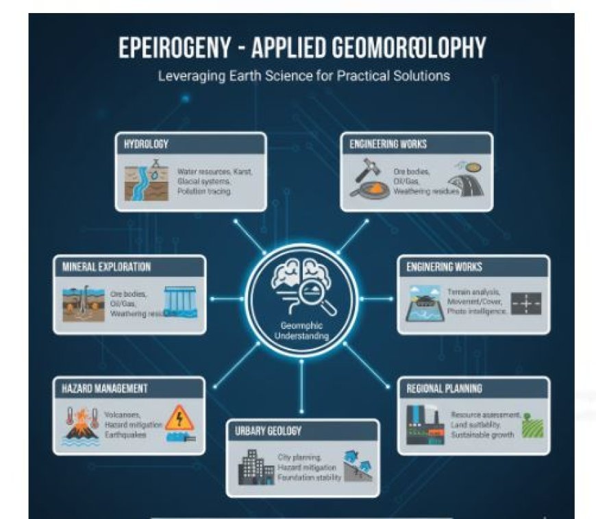
Applied Geomorphology
- For those who live on the earth's surface and have an impact on it, understanding landscapes can be very beneficial.
- If you understand landscapes correctly, they can help you understand the geologic past, structure, and lithology of an area.
- This is what D.K.C. Jones says applied geomorphology is: "the use of geomorphic knowledge to the study and resolution of issues related to land use, resource utilisation, and environmental management and planning."
- Yes, all geomorphological information is usually put to use, as R.G. Craig and John L. make things. Every new piece of information gives geomorphologists a better picture of how the earth works, which they can then use to evaluate resources, plan developments, find natural dangers, and lessen the effects of natural disasters.
- You can use your geomorphic skills and information in the following places:
looking into how geological and environmental processes affect people and their actions, as well as how to solve problems that come up because of these effects; - These include looking into how human actions affect landforms and environments and how to solve the problems that arise as a result.
- Taking care of resources and keeping an eye on changes in the geomorphic system to figure out what needs to be done to keep growth at a level that can be sustained.
Applications
- Here, we look at some of the ways that geomorphology can be used to solve problems that geologists, engineers, and planners often face.
Geomorphology and Hydrology
Geomorphology and Mineral exploration
Geomorphology and Engineering Works
Geomorphology and Military Geology
Geomorphology and Urbanisation
Geomorphology and Hazard Management
Geomorphology and Regional Planning
Geomorphology and Hydrology
- People can get water from a variety of places, such as underground streams, lakes, and rivers on the surface of the earth. The surface and groundwater in different stratographic and lithological zones are in different states.
- There is a wide range of limestone land, and the rock type affects its ability to hold water. There are two types of permeability in limestones: main and secondary. For primary permeability to work, there must have been original, interconnected gaps in the calcerous sediments that the rock formed from.
- Secondary (or acquired) permeability happens when the earth moves, like when it faults, folds, or warps, or when it dissolves or rusts.
- This secondary permeability changes a lot depending on the landforms in an area, being highest below and next to landform lows or valleys. A lot of the groundwater in karst areas stays in solution lines.
- The first stages of karst growth are not too different from the beginning stages of other types of settings with similar relief. But as the cycle goes on, a lot of water is sent to tunnels that have been made by solutions, and surface water levels drop.
- Karst rivers are the main source of water in these places. These sources might provide enough water to meet modest needs, but pollutants and bacteria could make the water less clean.
- If the spring water is polluted, the sources of the water should be found.
- It is possible to find the swallow holes and sinkholes that send water to underground drainage systems and come out as springs.
- utting a colouring substance, like fluorescein, into the water that comes in through nearby sinkholes or swallow holes and checking the different spring waters to find out where they come from are two ways to do this.
- It helps to know about the internal geology of the area because groundwater goes down the regional dip instead of up it.
- The geomorphology of a region where limestone is present affects how simple it is to access water there. It might not be difficult to find wells with high returns if the limestones are permeable enough and covered in sandstone.
- The water would also automatically be cleaned as it flows through the rock beds.
- If, on the other hand, the limestone is thick and hard with little mass permeability, groundwater will mostly move through secondary holes. In this case, the water flow might be low, or even if it is enough, it might be contaminated.
- For karst plains, there isn't a filtering cover, and sinkholes, swallow holes, or karst valleys in clastic rocks should make you doubt the purity of the water from nearby springs.
- The geomorphic history of an area, the features of glacial deposits, and the landform can help you figure out if there is groundwater potential there.
- A lot of water is expected to come out of outwash plains, valley trains, and intertill gravels.
- Because they are mostly clay, most tills aren't good water sources. However, they do contain layers of sand and grit that may hold and provide enough water for household use.
- Valleys that were buried during and between glaciers could be good places to get groundwater.
- You can tell if they are there or not by looking at the area's preglacial terrain and geomorphic past. Making bedrock topography maps of glaciated places is how you find buried rivers.
Geomorphology and Mineral Exploration
Geological structure is linked to mineral reserves. Geological features could be shown by the way the landscape looks in certain places.
Surface Expression of Ore Bodies
- Some ore bodies have clear surface expressions in the form of outcroppings of ore, gossan, or leftover minerals, or in the form of cracks, fractures, and zones of breccia.
- A slope that stands out, like the one in Broken Hill, Australia, could show where lead-zinc lodes are.
- Quartz lines could stand out because they are much less likely to wear away than the nearby rock that isn't silicified, like in Chihuahua, Mexico.
- Some veins, like calcite veins, and mineralized areas may be shown by depressions or signs of sinking.
Weathering Residues
- A lot of minerals that are important to the economy are left over from past or present geomorphic cycles. Geomorphology can help you find these minerals.
- Some ores of manganese and nickel, clay minerals, caliche, and iron ore may be left over after ageing. The rocks on the surface of the earth are always being worn down and worn away by weathering and erosion. The results of rock weathering may be useful in business.
- Commonly, weathering products that are left behind form on pleneplain or nearly pleneplain surfaces.
- Most of the time, these minerals can be found on top of surfaces that have been worn away by erosion since the Tertiary period.
- When aluminous minerals break down in the earth's crust, they leave behind bauxite. This can be either a small amount of solid aluminous material in dolomites and limestones or the minerals themselves.
Placer Deposits
- Placer deposits are made up of heavy metals that have been mixed together by chemical weathering or erosion of metal formations.
- Placer deposits of minerals are the result of specific geomorphic processes and may have their own unique geographic expression when they are found in certain topographical places.
- The type of rock that makes up the ground floor may affect how the placers are deposited.
- Residual placers, also known as "seam diggings," are left over from the weathering of quartz veins or stringers. They are usually small and break up into lodes.
- This type of placer is between residual placers and alluvial placers because it is made when leftover materials creep down slope.
- People have found these kinds of gold placers in California, Australia, New Zealand, and other places.
- The koelits are colluvial placers, and the kaksas are alluvial placers. Alluvial placers in Russia, Colombia, and other places give us about a third of the world's silver.
- Some of the most valuable minerals that can be found in alluvial placers are gold, tin, and diamonds.
- People find diamonds in the Vaal and Orange River districts of South Africa, the Lichtenburg area of South Africa, the Belgian Congo, and Minas Geraes,
- Brazil, by collecting rocks that have been washed from rivers. It is where about 20% of the world's diamonds are found.
- Gold has been found in Australia and Lower California, Mexico, in aeolian placers. Bajada placers grow in the gravel rim of a pediment and in the alluvial fans that meet at the bottom of a bajada.
- You're more likely to find them near the base of a mountain than on the flatter slopes of a basin fill.
- Gold and pearls have been found in beach placers in California and Alaska.
- Zircon has been found in India, Brazil, and Australia, and ilmenite and monazite have been found in Travancore, India.
- You can help find placers by digging and doing geomagnetic tests. Most of the time, a magnetic scan will be useful because magnetite is often found near gold.
- If the bedrock is a basic type with a stronger magnetic field than the placer gravels, magnetic 'lows' may show where the filled paths are.
- W.D. Thornbury says, "Knowledge of the bedrock geology, application of geophysical surveying, test drilling, and interpretation of aerial photographs are all important parts of the search for these buried placers.
- But the most important thing to know about this search is the geomorphic history of the area.
Oil Exploration
- Many oil fields have been found because of how striking their landscapes are. Mineral oil is thought to have been made when organic matter broke down and composted.
- Once the oil is formed, it gets stuck in rocks under structure traps or sedimentary traps.
- The permeable and impermeable layers are brought closer together by bent sedimentary layers called anticlines and synclines.
- Mineral oil is well-preserved in the upper permeable beds and the lower impermeable beds.
- Mineral oil is usually found in rock structures that are porous and allow water to pass through them.
- Below these rocks are layers of rocks that don't let water pass through them. Mineral oil can be found in sandstone and limestone because they are porous and allow oil to pass through them.
- The bed that doesn't let water through is made of rock. Tones may show an anticlinal or domal structure in places with thick tropical woods that make it impossible to see the land's surface.
- Oil is being looked for today by using more minor signs of geological features that are good for oil to build up.
- One such method is using overhead photos to look at the drainage of a landscape. It is necessary to have a complex understanding of how water drains in a certain place; a geomorphologist would likely have this knowledge.
- It is especially helpful to do a drainage study in places where rocks have low dips and the terrain has little relief.
- Leverson says that a lot of oil and gas sources are connected to unconformities, which are old erosion surfaces.
- This means that a petroleum geologist has to deal with areas that are underground.
- When old erosion surfaces shrink permeable beds and are then covered by layers, they turn into stratigraphic traps. Most of these happen along fault lines.
Geomorphology and Engineering Works
- Most engineering work involves figuring out some kind of geologic factor.
- The most common type of geologic factor is the shape of the land.
Road construction
- The landforms in the area would be the best way to figure out the best traffic lines.
- Among other things, it is important for road engineers to know about the area's geomorphic past, the strength of the top layers, and the rocks' lithological and sedimentary features.
- A path through a karst plain needs to be cut and filled many times, or the road will flood when it rains a lot because sinkholes will fill up with water from the surface.
- In order to prevent the large solutional holes that are likely to be present from weakening the abutments when building a bridge in a karst area.
- There are many kinds of engineering problems that come up in glacial areas.
- A flat plain is the best place for building a road, but cut-and-fill is needed to avoid winding paths where there are end-moraines, eskers, kames, or drumlins. Roads that will see a lot of traffic are not good for mucky areas, which are where lakes once were.
- Heavy traffic will make the plastic materials under the lake floor flow if a road is made across them as they are. This will cause "sinks" in the roadbed.
- To avoid this, the lacustrine fill might need to be dug out and replaced with something that won't move when it's loaded down.
- Places with a lot of slope, like those in late childhood and early adulthood, will need a lot of bridge building, cuts, and fills. Landslides, earth flows, and slumping are big problems in these places.
- More and more, the subgrade, or the type of dirt below the road surface, is important for highway buildings that will handle a lot of traffic because it affects how water drains below the highway.
- When there are light loads on a highway, two factors primarily determine its lifespan: the calibre of the aggregate used to build it and the texture and drainage of the earth below it.
- Because of this, understanding how soils react to different types of topography and parent material is important for building modern highways. It is important to understand soil profiles, which show how geomorphic factors and events have affected the land.
- Subgrades of silty clay with a high water table don't work well for highways. Materials that are grainy and have a low water table work best.
Dam Site Selection
- Putting together what we know about the geomorphology, lithology, and natural structure of landscapes would make choosing places to build dams a lot easier.
- Kirk Bryan says that the five main needs for good reservoir sites rely on geology.
- A large enough bowl that doesn't leak water.
- A narrow exit of the pond with a base that will make building a dam cost-effective.
chance to build a satisfactory and secure channel to move extra water. - The ability to get the materials needed to build a dam (this is especially important for clay dams).
- Reassurance that the pond won't lose its usefulness too quickly because of too much mud and silt building up in it.
- Having limestone ground, for example, might make it hard to build a wall.
- Differential solutions can make the ground surface uneven, and if we don't have a clear picture of what's below, it could cost us money that we don't need to spend.
- Building in a valley is better because of the size of the dam that needs to be built, but it isn't always a good place for the dam.
- In glaciated places with buried bedrock valleys filled with sand and gravel, the terrain on the surface may not accurately reflect what's going on below.
- A dam could be put in a narrow spot in a valley, between a valley wall and a branch end.
- This would be the most basic level. But it's possible that the terrain below isn't right; there could be a hidden preglacial valley with sand and grit in it. If the dam was built there, it would leak.
Building Air Strips
- Engineers need to be able to choose good places for airstrips so planes can land and take off, and a geomorphologist's knowledge of the land's features could be very helpful to the engineer.
- The best places for airstrips would have a large, flat area with strong geo-materials nearby. This is where a safe and ideal runway can be built.
- Also, the ground should have a slope that is almost level, there shouldn't be any flooding in the area, and it should be easy to see, maybe even without regular and thick fog.
- A structural map of the area where the airport is going to be built could show these features.
Locating Sand and Gravel Pits
- Sand and gravel are used in many building, business, and manufacturing ways.
- To find good places for sand and gravel pits, geologists will have to look at things like grade size variation, lithologic makeup, degree of weathering, amount of overburden, and consistency of the deposits. You can find sand and gravel in a riverbank, a river terrace, an alluvial fan and cone, talus, wind-blown, residual, or glacier deposit.
- All of them have unique topographic links and forms, as well as different natural traits and growth potentials.
- Figuring out what kind of deposit it is is important for figuring out how valuable it might be.
- It is important to know the amounts of different grade sizes because gravel is usually in higher demand than sand.
- This is especially true now that clay isn't being used as much in home building.
- It is possible that floodplain layers will have a lot of silt and sand in them, and they will have a lot of different types of slopes both horizontally and vertically.
- Alluvial fan and cone gravels have sharp edges and vary in size, especially near the tips of their shapes.
- Aside from being sharp, talus materials are also too big for most uses and can only be used in certain areas.
- Wind-blown sands may be good for getting sand, but they don't have any rocks in them.
- There isn't a lot of variety in the residual layers, and the rocks that are found there are probably too worn down to be used as aggregate in cement work.
- When iron-coated chert is used as gravel in large amounts, it usually makes things worse. It's also expected that the residual layers will not be very large.
- Valley trains with terraces and outwash plains are good places for pits because they don't have a thick layer of rock on top of them and are usually quite large.
Geomorphology and Military Geology
- Thornbury talks about how geomorphology is important in wartime.
- Compared to geomorphic data, rock data was more useful (Brooks, 1921). Stable ditches were the sites of the majority of combat during World War I.
- The most useful information was about the types of rocks that would be found in ditches, mines, and countermines, as well as about water sources and other geological materials that might be available.
- It is true that terrain helped the Allies move and plan their attack lines, but it is not fair to say that they used basic geomorphic understanding very much.
- As the blitzkrieg style of fighting grew in popularity during World War II, topography became more significant. This is because the success of a blitz depends a lot on how easy it is to move through the land.
- Because of this, the military has used the words "terrain awareness" and "terrain analysis" a lot more these days.
- It's possible that a geomorphologist doesn't know how to best use terrains for military activities, but his ideas about how terrains work are much better than those of others, including military specialists. He understands that landforms are the result of geomorphic and geologic processes interacting over time.
- Landforms are not just a bunch of random shapes; they have ordered relationships that show where they came from and reveal a lot about the geology and structure of the bedrock below, as well as the soils and plants that grow in a certain area.
- It was Erdmann (1943) who said that a geomorphologist has "an eye for the ground or an instinctive eye for configuration, the judgement of how far ground, seen or unseen, is likely to lie when you get to it...
- Geophysics and war are both based on the ground. Being able to read both topographic maps and overhead photos and having a general knowledge of the different types of terrain is important for planning military battles.
- Hunt (1950) said this about using aerial photos in this way: "Even where geologic maps are missing or are so small-scale that they are practically useless for tactical intelligence, geologic principles can be used to interpret the terrain from aerial photographs.
- If you can read vertical pictures, you can tell the difference between mountains, hills, lakes, rivers, trees, fields, and some kinds of swamps.
- In order to obtain comprehensive landscape intelligence, however, the images can and should be used to determine much more.
- To figure out the geography, it's important to know what kind of hill, plain, river, lake, etc. there is. With some confidence, the interpreter can then make guesses about the water supply, the type and depth of the soil, how easy it is to travel on, problems with ground drainage and other building issues, building materials, movement and cover, and many other factors that are necessary to get a good picture of the terrain.
- To sum up, overhead photos are helpful for creating landscape intelligence because they show the geology of the area.
- Just recognising a hill or other landform in a picture isn't enough to tell the whole story. What's really important is understanding what the landform means in terms of the type of ground and slope.
Geography and Building Cities
- Using geomorphological information to help build cities has become so important that it has grown into its own field, called urban geomorphology. R.U. says that this area of geomorphology is "the study of landforms and their related processes, materials, and hazards in ways that are useful for planning, developing, and managing urbanised places where urban growth is predicted." Make food.
- The stability, safety, basic needs, and later growth of a city or town rely on geomorphological features such as lithological and topographical features, water conditions, and geomorphic features. An urban geomorphologist's job starts long before cities are built.
- They do things like field surveys, landscape classification, identification, and choosing other places for people to live. The job of an urban geomorphologist is to study how natural events affect people living in cities and how cities change the environment, both during and after they are built.
- R.U. Cooke brought it up, saying, "Many geomorphological problems that planners and engineers haven't fully understood until now destroy and damage urban settlements in a wide range of environmental settings.
- For example, foundation materials drop in periglacial and dry lands in oil-rich states; weathering breaks down foundations; roads get damaged; flooding in humid subtropical regions damages buildings, and so on.
- Bad management or ignorance of the land's shape are contributing factors to all of these and many other issues. Not much thought goes into knowing the geomorphological conditions that existed before cities were built, especially in poor countries.
- Because of this, growth gets out of hand, which leads to illegal villages or shantytowns. It often leads to major problems in society and the world.
Geomorphology and Hazard Management
- Dangers are things that happen, whether they are natural or caused by people, that are too dangerous or come as a surprise. Chorley says that a geomorphic danger is "any change, natural or man-made, that may affect the geomorphic stability of a landform in a way that places living things at risk.
- As the earth moves, faults, folding, warping, rising, and falling can happen over time. These risks can also come from changes in the plant growth and hydrologic system caused by climate change. Risks that happen more quickly and directly include earthquakes, landslides, avalanches, floods, and volcanic events.
- Knowing about geomorphology can help you find and predict these kinds of dangers, as well as figure out how to handle them properly.
- We regularly record seismic events and earth tremors using seismic methods. We also regularly record the ground's surface, mostly by using tilt metres.
- We keep an eye on the temperature of crater lakes, hot springs, geysers, and fumaroles, as well as the gases that come out of these places. Lasers are used to track changes in the shape of dormant or extinct volcanoes, and we measure local gravity and magnetic fields and their trends.
- An in-depth study of the terrain and the location of possible explosion sites can help predict the direction of the lava flow more accurately.
- It is important to know about the geomorphic features of a river system and how it flows.
- Controlling river floods may be possible by studying things like channel shape, channel morphology, and pattern, as well as river metamorphosis, bank morphology, and more.
- These include these steps:
- To keep the water from heavy rain from going back into the rivers for longer.
- To speed up the flow of water (by smoothing out the winding pathways).
- To change the direction of water flow (through diversion routes).
- One way to lessen the damage storms cause is to build protected embankments.
- To let people know when floods are going to happen.
- If you don't know how erosion works in the upper catchment area and how much sediment the river carries, building levees to keep the flood water in the valley could be disastrous.
- For example, if the rate of erosion is very high in the upper catchment area, causing a high sediment load, there will be more sedimentation in the valley, which will cause the river bed to slowly rise, which could cause sudden flash floods whenever the levee is breached.
- It's possible for earthquakes to happen naturally or because of people.
- To find places that are weaker and more likely to have earthquakes, it is important to know how stable the land is and how buildings like dams and lakes can change the stability of the rock.
- In the same way, studying the geomorphic structure of hill slopes and the rock types that form them helps us figure out how stable or unstable the slopes are. With this information, it would be easier to find and map unsteady hill slopes that aren't good for building homes or roads.
Geology and planning for the region
- Geomorphology can be used in planning for regions. For a country's economy to grow in a balanced way, each area needs to have a clear idea of what it has to offer in terms of natural and human resources.
- Smart regional planners will be interested in detailed information on geography, soils, hydrology, lithology, and terrain features. This way, they can come up with the best growth plans for the area.
What's Your Reaction?


