GEOMORPHOLOGY AND HYDROLOGY
Geomorphology studies landforms, while hydrology explores water flow on Earth's surface and underground.
0
79
Geomorphology and Hydrology
- People can get water from a variety of places, such as underground streams, lakes, and rivers on the surface of the earth. The surface and groundwater in different stratographic and lithological zones are in different states.
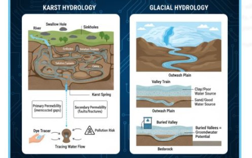
- There is a wide range of limestone land, and the rock type affects its ability to hold water. There are two types of permeability in limestones: main and secondary. For primary permeability to work, there must have been original, interconnected gaps in the calcerous sediments that the rock formed from.
- Secondary (or acquired) permeability happens when the earth moves, like when it faults, folds, or warps, or when it dissolves or rusts.
- This secondary permeability changes a lot depending on the landforms in an area, being highest below and next to landform lows or valleys. A lot of the groundwater in karst areas stays in solution lines.
- The first stages of karst growth are not too different from the beginning stages of other types of settings with similar relief. But as the cycle goes on, a lot of water is sent to tunnels that have been made by solutions, and surface water levels drop.
- Karst rivers are the main source of water in these places. These sources might provide enough water to meet modest needs, but pollutants and bacteria could make the water less clean.
- If the spring water is polluted, the sources of the water should be found.
- It is possible to find the swallow holes and sinkholes that send water to underground drainage systems and come out as springs.
- utting a colouring substance, like fluorescein, into the water that comes in through nearby sinkholes or swallow holes and checking the different spring waters to find out where they come from are two ways to do this.
- It helps to know about the internal geology of the area because groundwater goes down the regional dip instead of up it.
- The geomorphology of a region where limestone is present affects how simple it is to access water there. It might not be difficult to find wells with high returns if the limestones are permeable enough and covered in sandstone.
- The water would also automatically be cleaned as it flows through the rock beds.
- If, on the other hand, the limestone is thick and hard with little mass permeability, groundwater will mostly move through secondary holes. In this case, the water flow might be low, or even if it is enough, it might be contaminated.
- For karst plains, there isn't a filtering cover, and sinkholes, swallow holes, or karst valleys in clastic rocks should make you doubt the purity of the water from nearby springs.
- The geomorphic history of an area, the features of glacial deposits, and the landform can help you figure out if there is groundwater potential there.
- A lot of water is expected to come out of outwash plains, valley trains, and intertill gravels.
- Because they are mostly clay, most tills aren't good water sources. However, they do contain layers of sand and grit that may hold and provide enough water for household use.
- Valleys that were buried during and between glaciers could be good places to get groundwater.
- You can tell if they are there or not by looking at the area's preglacial terrain and geomorphic past. Making bedrock topography maps of glaciated places is how you find buried rivers.