DRAINAGE SYSTEM OF INDIA
India's drainage system consists of the Himalayan rivers (Indus, Ganges, Brahmaputra) flowing east into the Bay of Bengal and the Peninsular rivers (Godavari, Krishna, Narmada, Kaveri) flowing east or west
0
79
Indian Drainage System
- India has many small and large rivers that drain the country. It's what happened when the three main physiographic groups evolved, along with the type and traits of hustling.
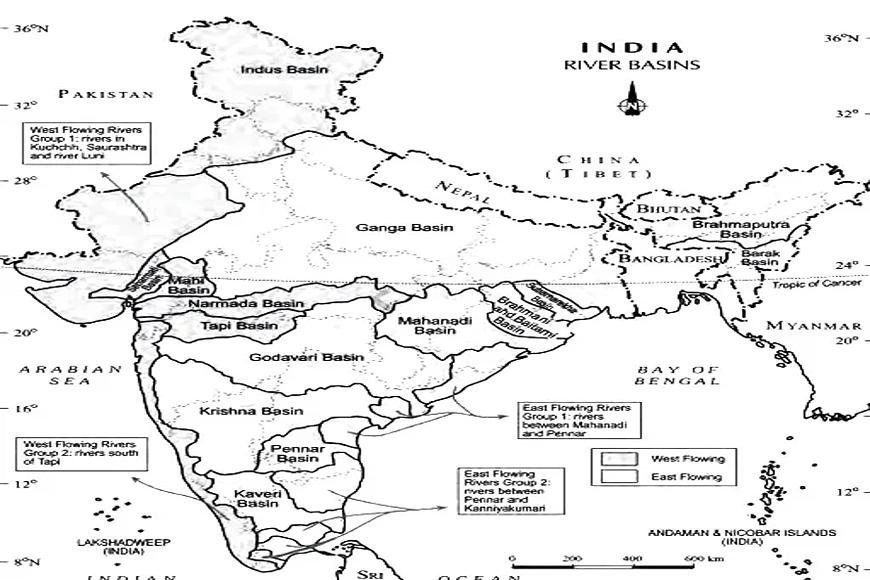
- The river valleys of the Ganga, Indus, and Brahmaputra are all part of the Himalayan drainage system. Five rivers—the Narmada, the Tapi, the Mahanadi, the Godavari, the Krishna, and the Kaveri—flow through the peninsular plains.
- The Arabian Sea gets the other 10% of India's surface water, while the Bay of Bengal gets 90%.
- There is a water split that goes across the Western Ghats, the Aravallis, and the Yamuna Sutlej, which separates between the draining systems that go into the Arabian Sea and the Bay of Bengal.
- India has many sewage systems, both big and small. The physical features of the region have an effect on it.
- India's water system is split into two groups based on where it comes from, what it is made of, and how it works.
The Himalayan drainage system
The Peninsular drainage system
- The Himalayan Drainage System includes Himalayan rivers.
- The Indus, Ganga, and Brahmaputra rivers are all in the Himalayas.
- Since both rain and melting snow feed the rivers in this system, they are always present.
- These rivers flow roughly, carving out V-shaped valleys, rapids, and waterfalls along the way.
- When rivers enter the plains, they leave behind open slopes, oxbow lakes, flood plains, braided channels, and deltas, to name a few.
- These three rivers make up river systems because they are so long and have so many big streams that flow into them.
- The river systems below are all part of the Himalayan Drainage System.
The Indus River System
- One of the largest rivers in the world, it starts in Tibet near Lake Mansarovar and flows into India through the Ladakh region of Jammu and Kashmir.
- It flows through Baltistan, Gilgit, and other parts of Pakistan before meeting the Zaskar, Nubra, Shyok, and Hunza rivers east of Karachi in the Arabian Sea.
- The slope of the Indus plain is pretty shallow. With 2900 km, it is the longest river in the world.
- Punjab, Himachal Pradesh, and Jammu and Kashmir are all in the Indus basin.
The Ganga River System
- It makes the world's largest wetland, the Sundarbans, and the Ganga 2,500 km long. The Ganga starts in Gangotri, which is in Bhagirathi's Glacier. This is called the "Bhagirathi," from where it starts to where it meets the Alaknanda in Devaprayag.
- The Ganga starts in the hills and runs through the fields of Haridwar. Four important rivers flow into the Yamuna: the Ghaghara, the Gandak, and the Kosi.
The Brahmaputra River System
- Nepal is where it starts. Along the border with Tibet, it runs parallel to the Himalayas. In a straight line, it runs eastward along the Himalayas.
- It goes around Namcha Barwa and into Arunachal Pradesh, India.
- The "Dihang" is made up of the Dibang, the Lohit, and many other rivers that rise in Assam and run into the Brahmaputra.
- Unlike the other northern rivers, the Brahmaputra fills up with a lot of silt, which makes the river rise.
- The Peninsular Rivers serve as a drainage system for the peninsula.
- A number of rivers run through the peninsular plains.
- The mountains in the middle of India are where the Narmada and Tapi rivers start.
- After going west for a while, they reach the Arabian Sea.
- A small valley forms between the Vindhyas in the north and the Satpura Hills in the south. This is where the Narmada flows. It runs south of the Satpura Hills.
- Mahanadi, Godavari, Krishna, and Kaveri are some other important rivers that run east and join the Bay of Bengal. The Godavari is the largest river on the peninsula.
The Mahanadi Basin
- Mahanadi rises in the hills of Chhattisgarh. It goes to the Bay of Bengal by going through Odisha. The river flows for about 860 km.
- The Hasdeo, Mand, Jonking, and Tel rivers are some of its main streams.
- The Maikala range is to the west, the Central India hills are to the north, and the Eastern Ghats are to the south and east.
The Tapi Basin
- There is a rift valley there that runs next to the Narmada but is not as long.
- About 724 km long, the river. Parts of Madhya Pradesh, Gujarat, and Maharashtra are in its area.
- About 79% of it is in Maharashtra, 15% is in Madhya Pradesh, and 6% is in Gujarat.
The Godavari Basin
- From Maharashtra's Nasik area to the Bay of Bengal, the Godavari is the peninsula's largest river.
- There are 1,465 km of water. Maharashtra, Madhya Pradesh, Chhattisgarh, Odisha, and Andhra Pradesh all get water from this river.
- The Penganga, Indravati, Pranhita, and Manjra rivers are its major sources of water.
The Narmada Basin
- It starts at a height of 1,057 m in Amarkantak, Madhya Pradesh, and goes west across the rift valley. One thousand three hundred twelve kilometres long is the river.
- In the rift valley, which is between the Vindhyan range in the north and the Satpura range in the south, it moves westward.
- The main rivers that feed into the river are the Hiran, the Orsang, the Barna, and the Kolar.
- Some parts of Madhya Pradesh, Maharashtra, and Gujarat are in the Narmada area.
Kaveri/Cauvery Basin
- Arkavathi, Hemavathi, Bhavani, Kabini, and Amravati are the main rivers that flow into the Kaveri River from the Brahmagiri mountains in Karnataka's Kodagu district.
- It goes southeast through Karnataka, Kerala, and Tamil Nadu. Pondicherry is where it ends in the Bay of Bengal.
- The River Kaveri makes Shivasamudram Falls, which is the second biggest drop in India.
- The outflow for the river gets rain during both the summer and the monsoons' retreat. Because of this, the river's water level stays mostly the same all year, unlike some other peninsular rivers.
The Krishna Basin
- The Krishna River, which springs near Mahabaleshwar in Sahyadri, is the peninsula's second-largest east-flowing river.
- The Koyna, Tungabhadra, and Bhima rivers are its principal tributaries. It is 1,401 km long.
- It flows through Maharashtra, Karnataka, Telangana, and Andhra Pradesh before entering the Bay of Bengal.