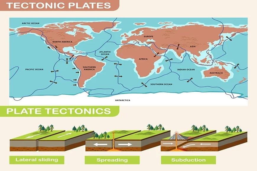
SEVEN MAJOR TECTONIC PLATES
The 7 Major Tectonic Plates (African, Antarctic, Eurasian, Indo-Australian, North American, Pacific, South American) that Shape Our Planet.
0
165
Earth has tectonic plates
- The majority of the earth's surface and the Pacific Ocean are made up of seven primary plates (Pacific, North America, Eurasia, Africa, Indo-Australian, Antarctica, and South America).
- There are seven major tectonic plates.

Pacific Plate
- The Pacific Plate is the largest of the lithospheric plates, covering 103 million square kilometers.
- Except for areas around New Zealand and parts of California west of the San Andreas Fault, the Pacific Plate is almost exclusively oceanic.
- Along its boundary, the Pacific Plate contains all three types of plate tectonic boundary types. It has convergent, divergent, and transform boundaries with other tectonic plates.
- The Pacific Plate is always in motion. The Pacific rate of motion is 5 to 10 cm per year on average. However, it moves more than 10 cm in some places. The Hawaiian Islands are said to have formed as a result of the Pacific Plate's nature. The Hawaiian Islands were originally volcanoes that formed above water over millions of years.
- The Pacific Plate is home to the Ring of Fire, also known as the Circum-Pacific Belt. A 25,000-mile stretch of volcanoes and seismically active areas surrounds the Pacific Ocean.
North American Plate
- The North American Plate is the world's second-largest tectonic plate, with an area of 76 million square kilometers.
- The North American Plate began to form over 300 billion years ago, when the Earth was much warmer.
- This plate includes not just the continent of North America but also a portion of the Atlantic Ocean.
- Greenland, the northern Caribbean, and sections of Siberia, Iceland, and the Azores in Portugal are all part of the continental crust. It also includes Japan's northernmost island.
- The North American Plate's margins exhibit all three types of tectonic boundaries:
- The San Andreas Fault is a transverse border between the Pacific and North American plates.
- A divergent barrier in the middle of the Atlantic Ocean where the North American Plate meets the Eurasian Plate. This also resulted in the formation of the Mid Atlantic Ridge, a network of undersea ridges in the Atlantic.
- The North American Plate is moving southwestward at a rate of around 2.3 centimeters per year.
- This may appear to be slow motion, yet over geologic time spans, these movements can result in spectacular geological sub-provinces.
Eurasian Plate
- The third-largest tectonic plate, the Eurasian Plate, spans all of Asia and Europe. England, Germany, Norway, Sweden, Finland, Austria, Poland, and Ukraine are among the European countries represented on the plate. Kazakhstan, Uzbekistan, Turkmenistan, and Mongolia are also members of the Eurasian Plate.
- It is 67.8 million square kilometers in size and is sandwiched between the North American and African plates on the north and west edges.
- The Arabian, Indian, and Sunda plates border it on the south, and the subducting Philippine Sea plate borders it on the east.
- Volcanoes, triple junctions, seismically active faults, flood island basalts, and accretionary wedges abound on the Eurasian Plate.
- Its southern and eastern limits are the most active tectonically.The raising of the Himalayas is the most visible geological structure linked to the Eurasian Plate.
- The Himalayan mountain range is the result of a 50 million-year-old collision between the Indian Plate and the Eurasian Plate.
- The Eurasian Plate is migrating away from the North American Plate at a rate of 3cm per year on average.
African Plate
- The African Plate, with an estimated extent of 61.3 million square kilometers, is the world's fourth-biggest plate tectonic boundary.
- It encompasses not just the entire African continent but also significant portions of the Atlantic and Indian Oceans.
- Pangaea, the huge supercontinent that existed around 300 million years ago, was formerly centered on Africa.
- South Africa, India, and Antarctica have since separated from Africa. As a result, the African plate has three mid-ocean ridges (divergent boundaries) running along its eastern, southern, and western edges.
- The continent slips away from these boundaries, and hot lava from volcanoes seeps up, forming new seafloor.
- The convergent boundary on the northern side is where the African plate is subducting beneath the Eurasian plate.
- The African plate appears to be splitting apart quicker than geologists predicted.
- The East African Rift (EAR), also known as the Afro-Arabian Rift Valley, is the result of divergence between Eastern and Western Africa.
- The growing tear is causing scientists to question if Africa is made up of two tectonic plates or if the continent is splitting in two.
- According to a recent article published in Nature Communications, substantial parts of the African Plate have vanished over the last 200 million years.
Antarctic Plate
- The Antarctic Plate is not just the fifth-largest plate on the planet, but it is also the world's southernmost plate.
- It comprises the continent of Antarctica and extends further outward under the surrounding waters, covering approximately 60.9 million square kilometers.
- Gondwanaland, the southern half of the Pangaean supercontinent, once included Antarctica.
- Antarctica gradually separated from the other continents and drifted southward until it arrived at its current location around 30–60 million years ago.
- The African Plate, the South American Plate, the Nazca Plate, the Indo-Australian Plate, and the Scotia Plate all border the Antarctic Plate. It also forms the Pacific-Antarctic Bridge by bordering the Pacific Plate.
- Tectonically, the Antarctic Plate is split into two separate parts: the West Antarctic, which is made up of several microplates that are partly underwater, and the East Antarctic, which is a huge craton that is split in two by the West Antarctic Rift System.
- The plate is expected to advance at a snail's pace towards the Atlantic Ocean, moving only 1cm per year.
Indo-Australian Plate
- It is the world's second-smallest tectonic plate, covering around 58.9 million square kilometers.
- It was produced about 40–43 million years ago when the Indian Plate and the Australian Plate merged.
- The Indo-Australian Plate runs from the Australian continent to the Indian subcontinent. It also covers Antarctica in the south, the Indonesian Islands and New Guinea in the north, and New Zealand in the east.
- The Indo-Australian Plate is currently shifting to the north-east at a rate of roughly 5-7 centimeters per year.
- Subduction along its northern flanks as the plate is subducted along the Pacific Ring of Fire is one of the causes driving the movement.
- The upper mantle of the plate, on the other hand, is moving at a slower rate—roughly 2–3 centimeters per year.
South American Plate
- The South American plate is the smallest tectonic plate, covering 43 million square kilometers.
- It is one of the tectonic plates that separated Pangea about 200 million years ago.
- It consists of both a continental (South America) and an oceanic (South Atlantic) component.
- The African plate, the Nazca plate, the Antarctic plate, the Scotia plate, the Caribbean plate, and the North American plate all encircle the plate in its east, west, south, and north directions, respectively.
- The South American Plate and the Nazca Plate have the longest convergent boundary, generating the Andes Mountains, which stretch over 7000 kilometers.
- Convergence boundaries have more active volcanoes and tectonic activity; the Andes Mountain range has 200+ active volcanoes as a result of the convergence of the Nazca plate and the South American plate.