GLACIAL LANDFORMS
Erosional Landforms: Cirques, U-shaped Valleys, Fjords, Horns, Aretes. Depositional Landforms: Terminal Moraines, Recessional Moraines, Drumlins, Kettles
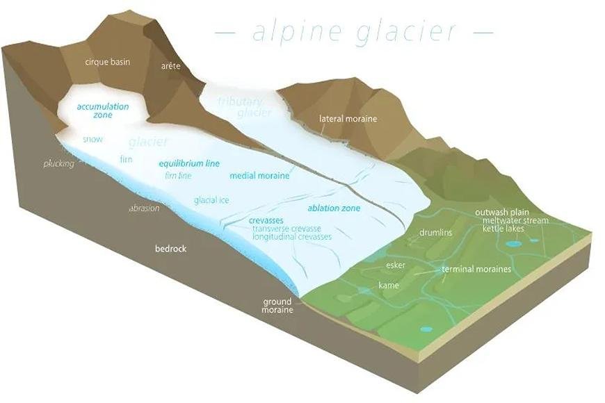
Glacial Landforms
- Glaciation often causes erosional characteristics in the highlands and depositional ones in the lowlands.
- It erodes its valley through two processes: plucking and abrasion.
- Plucking: A glacier freezes the joints and beds of underlying rocks, tearing them out and dragging them away.
- Abrasion: The debris frozen into the valley floor scratches, scrapes, polishes, and scours it.
Glacial Landforms
Erosional

Snout or Glacier Terminus
- The terminus, also called the toe or snout, is the lower end of a glacier. It is the end of the glacier at any given time.
Corrie & Cirque
- The downslope movement of a glacier from its snow-covered valley head and the intensive shattering of the upland slopes tend to produce a depression where snow or firn accumulates.
- Plucking and abrasion further deepen the depression into a steep horseshoe-shaped basin called Cirque (in French), CWM (in Wales), and Corrie (in Scotland).
- When cirque basins cover the top on all sides, horns form a single pyramidal peak that results.
Aretes and Pyramidal Peaks
- When two cirques cut back on opposite sides of the mountain, they make arêtes, which are sharp slopes.
- When three or more cirques cut back together, they make a pyramidal peak, which looks like a horn.
Begschrund
- At the head of a glacier, where it begins to leave the snowfield of a corrie, a deep vertical crack called a Bergschrund or Rimaye opens up.
- This happens in summer when, while the ice continues to move out of the corrie, there is no new snow to replace it.
- In some cases, not one but several such cracks occur, posing a major obstacle to climbers.
Roche moutonnée
- It essentially consists of a resistant remnant rock hummock or mound that has striated ice movement.
- Abrasion has smoothed out its upstream or stoss side, while plucking has roughened out its downstream or leeward side and made it significantly steeper.
- Plucking is thought to have happened on the leeward side because the glacier moving over the stoss slope lowered the pressure, letting water freeze again on the lee side and lifting the rock away.
Crag and tail
- A crag and tail is a larger rock formation than a Roche moutonnee.
- It is a harder rock mass than the surrounding rock, much like a Roche moutonnee.
- A crag is a mass of rock with a steep upward slope that shields the softer, leeward slope from the advancing ice.
- As a result, it has a gently scattered tail scattered with eroded rock debris.
Nunatak
- A nunatak is a mountain top or ridge that protrudes from an ice sheet or glacier that otherwise covers the majority of the mountain or ridge. They are also known as glacier islands.
- Nunataks are mountain peaks or other rock formations that are visible above a glacier or ice sheet.
Paternoster Lakes
- A paternoster lake is a group of glacial lakes linked together by a single stream or a braided stream system.
- Paternoster lakes occur in a U-shaped valley's low dip.
- Recessional moraines, also known as rock dams, are what cause paternoster lakes to form when the ice advances, retreats, and then melts upstream.
U-shaped glacial troughs and ribbon lakes
- Glaciers on their downward journey are fed by several corries that scratch and grind the bedrock while straightening out any protruding spurs.
- The interlocking spurs are thus blunted to form truncated spurs as the valley floor deepens.
- As a result, the glaciated valley takes the shape of a U, with a wide, flat floor and very steep sides.
- The deep areas of these long, narrow glacial troughs may fill with water once the ice melts, generating ribbon lakes, also known as trough lakes or finger lakes.
Hanging Valleys
- Because the main valley includes a much larger glacier, it has been eroded considerably more than the branch valley.
- After the ice has melted, a tributary valley hangs above the main valley and plunges down as a cascade.
- Hanging valleys are tributary valleys that can produce a natural head of water for generating hydroelectric power.
Rock Basins and Rock Steps
- Lakes eventually fill the rock basins that a glacier excavates and erodes in an uneven pattern, creating valley troughs.
- Where a tributary valley meets a main valley, the extra weight of the ice in the main valley cuts deeper into the valley floor, making rock steps.
- A series of these rock steps may also form where the bedrock is resistant to glacial erosion to varying degrees.
Fjord
- If the glacier runs all the way down to the sea, it dumps its moraine burden into the sea.
- If pieces break off as icebergs, moraine debris will be dumped only after the icebergs melt.
- A fjord, a deep, steep side entrance that is typical of the Norwegian and Chilean coasts, results from the sea drowning the lower end of the trough.Depositional Glacial Landforms

Boulder clay or glacial till
- This is an unsorted glacial deposit composed of a variety of eroded materials, such as boulders, sticky clays, and fine rock flour.
- It is spread out in sheets rather than mounds and forms gently undulating tills or drift plains with monotonous landforms.
Erratics
When the ice melts, boulders of various sizes remain stranded in the deposition regions.
They are known as erratics because they are made of materials that are completely different from those of the regions through which they have been transported.
It is useful for detecting the source and direction of ice movements, although their presence in large quantities makes farming difficult.
They are also known as perched blocks because they are frequently found sitting in perilous places after being dropped by ice.
Moraines
- Moraines are made up of broken rock fragments that are lodged in glaciers and carried down the valley by frost action.
- Those that fall on the glacier's flanks generate lateral moraines.
- When two glaciers meet, their inner lateral moraines merge to produce a medial moraine.
- When the glacier melts, the rock pieces carried along beneath the frozen ice are dropped and scattered across the valley floor as ground moraine.
- When the glacier reaches the valley's bottom, it melts, and the mound of transported materials left behind at the snout is known as the terminal moraine or end moraine.
- End moraines may be deposited in numerous successive waves when the glacier melts back in stages, forming a succession of recessional moraines.
Drumlins
- Drumlins are oval-shaped hills that grow beneath a glacier or ice sheet and are oriented in the direction of ice flow.
- They are common in historically glaciated locations, particularly in Canada, Ireland, Sweden, and Finland.
- They are small hills that are up to 1.5 km long and 60 mm high. They look higher on the side facing the wind and lower on the side facing the windward direction. This shape is often called a "basket of eggs" topography.
- Basket of egg topography refers to the topography of drumlins, which are typically found in groups.
- Drumlin fields are locations with a large number of drumlins.
Eskers
- Eskers are sinuous ridges comprised of glacial material, primarily sands and gravel, deposited in glacial tunnels by meltwater currents.
- Glacial tunnels represent the historical locations of subglacial meltwater streams.
- Their orientation is normally parallel to the path of glacier flow, and they can reach lengths of more than 100 kilometres.
Outwash Plains
- Streams of still ice mass are responsible for driving fluvial glacial deposits out of terminal moraines.
- The melt waters sorted and redeposited the material, which was mostly sand and other fine particles.
- These sandy plains are frequently utilised for specialised agriculture, such as potato production.
Kettle lake
- Depressions arise when deposition occurs in the shape of alternating ridges.
- Glacier retreat creates shallow, sediment-filled pools of water.
Kames
- Kames are little, rounded sand and gravel hillocks that cover a portion of the plain.
- Kames are frequently connected with kettles, and this is referred to as kame and kettle topography.
- Kame is also known as Hummock.