ACROSS TRACK AND ALONG TRACK
Learn about the differences between across-track and along-track scanning systems in remote sensing, and their applications.
0
180
Satellite Imaging Techniques: Across-Track and Along-Track Scanning
- Satellites employ advanced scanning equipment to obtain photographs of Earth from orbit.
- There are two common methods used for this type of imaging: across-track scanning and along-track scanning.
- These strategies enable the collection of precise Earth observations using several methods.
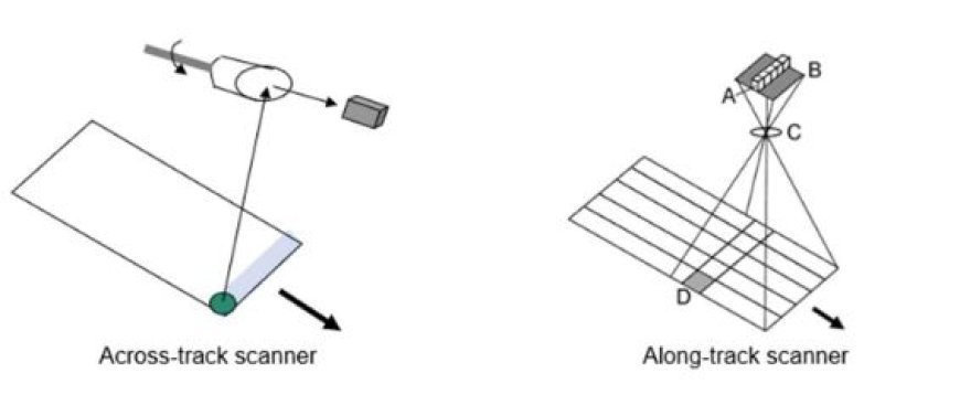
Across-Track Scanning
- Across-Track Scanning refers to the process of scanning or moving in a direction perpendicular to the track or path being followed.
- Across-track scanning functions in a manner similar to the act of drawing parallel lines on paper with a ruler. The following summarizes the procedure:
- Mechanism: A sensor affixed to the satellite moves along its orbital trajectory, systematically gathering data in a sequential manner.
- The satellite advances incrementally after scanning each line, ultimately constructing a comprehensive image by piecing together these lines in a mosaic pattern.
- Applications: This technique is frequently utilized by several Earth observation satellites, particularly those deployed for meteorological objectives.
- Benefits: The use of across-track scanning allows for efficient and quick covering of large regions.
- Drawbacks: The process of acquiring data happens in separate lines, which may lead to slight gaps or overlaps between neighboring lines.
Along- Track Scanning
- Along-Track Scanning refers to the process of scanning or imaging an area along a certain path or track.
- Along-track scanning is similar to the continuous motion of painting on a canvas.
The approach is outlined as follows:
- Mechanism: A sensor mounted on the satellite traverses its orbital path, conducting a continuous scan of a specific area on the Earth's surface.
- This technology operates in a manner akin to a substantial, mobile camera lens.
- Satellites equipped with radar imaging systems often employ along-track scanning in their applications.
- Benefits: This method produces a continuous view without any interruptions and allows for quick data collection as the satellite moves forward.
- Drawbacks: The sensor necessitates operating at elevated velocities and maintaining exact synchronization with the satellite's movement in order to guarantee precise data acquisition.
The significance and practical uses
- Comprehending these scanning techniques is essential for effectively understanding satellite data. This understanding enables scientists to properly utilize the data for many purposes, such as:
- Weather Forecasting: The technique of across-track scanning is used to detect cloud formations, precipitation patterns, and other meteorological phenomena.
- Environmental Monitoring: Both cross-track and along-track scanning are employed to observe changes in the environment, including deforestation, pollution, and modifications in vegetation.
Maps
- Mapping and Navigation: The use of these scanning technologies produces highly detailed images of the Earth's surface, which are valuable for creating maps and aiding in navigation.