APPLICATIONS AND CHALLENGES IN VISUAL INTERPRETATION
Learn about the applications and challenges of visual interpretation in remote sensing, including image analysis and feature recognition.
Applications and Challenges In Visual Interpretation
- Remote sensing is a scientific branch that gathers information about the Earth's surface and atmosphere by evaluating data acquired by sensors that are not physically present in the region under study.
- Visual interpretation is an important aspect of this discipline, as it involves examining and interpreting the visual representations of the data. This method is critical in a variety of applications and raises substantial concerns.
1. Applications of Visual Interpretation in Remote Sensing.
Visual interpretation is an important tool in a wide range of remote sensing applications, which include:
a. Land Use and Land Cover Classification: Using visual patterns and spectral signatures, this program divides the Earth's surface into many land cover groups, including forests, agricultural fields, urban areas, and aquatic bodies. It is critical to monitor the environment, develop cities, and manage resources effectively.
b. Change Detection: By comparing photographs collected at different times in time, visual analysis allows for the identification of changes in land use, vegetation expansion, and infrastructural development. This procedure is critical for assessing environmental repercussions, controlling natural catastrophes, and tracking the impact of human activity.
c. Geographic Feature Extraction: This process comprises identifying and demarcating geographic features such as roads, buildings, and waterways using remote sensing images.
- Cartography, geographic information system (GIS) mapping, and the construction of transportation and communication networks have all made use of this instrument.
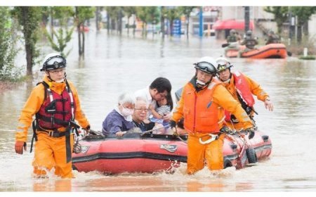
d. Disaster Management: During natural catastrophes such as floods, fires, and earthquakes, the use of satellite images for visual analysis allows for a quick and exact assessment of damage.
- This study may help disaster response teams identify affected areas and prioritize resource distribution.
b. Military and Intelligence Gathering: Visual interpretation is employed for national security purposes, identifying and tracking military locations, troop movements, and other critical strategic information.
2. Difficulties with Visual Analysis of Remote Sensing Data
Although visual interpretation plays an important part in remote sensing, it is not without challenges, which may be grouped into the following categories:
a. Data Complexity: Due to the vast volume and complexity of remote sensing data, specialized approaches are required to successfully analyze and interpret it. This entails handling a variety of sensor kinds, spatial resolution levels, and time scales.
b. Variability in Spectral Signatures: Objects' spectral signatures can vary significantly due to factors such as changes in lighting conditions, atmospheric interference, and sensor calibration changes. These variances make it difficult to recognize and classify features consistently.
c. Subjectivity: Human interpreters may include bias or inconsistency into their analysis due to their own perception and interpreting abilities. This may result in variations in the recognized traits and their classification.
d. Spatial resolution limitations: While high-resolution pictures provide complex details, they are susceptible to'mixed pixels', which arise when multiple land cover categories are present inside a single pixel. This may complicate the categorizing procedure. On the other side, photos with low resolution may obscure critical finer features required for proper analysis.
e. Temporal resolution limitations: Some sensors provide regular updates, while others may have long pauses between image captures. This can hamper the detection of rapid changes or the investigation of dynamic systems.
- Data integration entails combining data from several sensors or sources, which may create challenges due to geometric distortions, radiometric calibration, and spectrum variations.
- These impediments have the potential to affect the accuracy of visual judgments.
- Automation and Machine Learning: While automated approaches can increase the efficiency and impartiality of visual interpretation, developing algorithms capable of replicating human
level comprehension and decision-making remains difficult.
- Training and talent: Proficient interpreters are required to appropriately analyze remote sensing data, and the scarcity of such talent may hinder the use and advancement of visual interpretation systems.
i. Data Accessibility and Security: Certain remote sensing data may be unavailable due to privacy or national security issues, which may impede research and analysis in regions requiring specific safeguards.
3. Managing Difficulties in Visual Analysis
Several techniques can be used to address these issues:
- Advancement of Sophisticated Algorithms: Using machine learning and artificial intelligence, automated image analysis approaches may dramatically improve the precision and efficacy of visual interpretation while reducing human error and subjectivity.
- Methodology Standardization: Using standardized techniques for data processing and interpretation reduces discrepancies among analysts and improves the comparability of findings between research.
- Integration of Multi-Spectral and Multi-Temporal Data: Combining data from many sensors and time periods can improve our understanding of the region of interest, making it easier to categorize complex traits and identify changes.
d. Integration of Remote Sensing with Other Data Sources: Supplementary data, such as topographic maps, weather reports, and field observations, can improve the context and trustworthiness of visual interpretations.
e. Ongoing Education and Training: Consistently improving interpreters' abilities and providing advanced training can ensure that they are equipped to manage the evolving complexities of remote sensing data.
f. Resolving Data Access and Security Issues: Governments and institutions should work together to develop policies that strike a balance between making data available for scientific purposes and resolving security and privacy concerns.
What's Your Reaction?


