MID OCEANIC RIDGES
Midoceanic ridges: Earth's longest mountain range formed by seafloor spreading and volcanic eruptions.
Mid-Ocean Ridges
- The movement of plates created a mountain range under the ocean called the Mid-Oceanic Ridge.
- There are two mountain ranges that make up the area, and a sizable valley divides them. Some mountain ranges have tops that are higher than 2,500 meters, or even higher than the ocean.
- To learn more about the ocean floor, many underwater trips and surveys have been done.
- These underwater adventures have shown us a lot of beautiful and unique things in the lakes and seas.
- The majority of people who witness tsunamis agree that an earthquake under the sea is to blame. It's also true that the Earth's seismic processes happen where two plates meet.
- These are different pieces of rock that are found below lakes and seas.
- Modern maps of the ocean floor have helped us learn a lot more about these marine features.
- They also helped us understand the ideas behind the seismic processes that are happening on Earth right now.
- The ocean's shapes are different based on where they are, where they came from, their anatomy, their lithology, and how the water masses move.
Formation of Mid-Ocean Ridges
- The Mid-Ocean Ridges are one of the most unique features of these rocks.
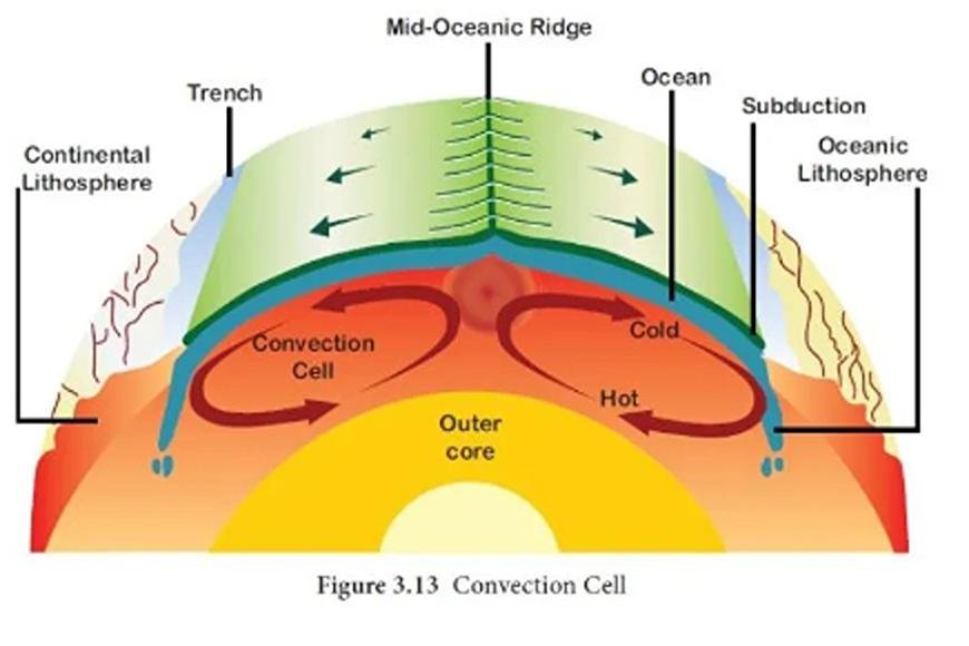
- As the name suggests, the Mid-OceanO Ridges are mostly found in the middle of ocean basins, where the edges of plates are moving apart.
- Plate Tectonics Theory has found many important geologic processes, such as how convection currents are released along divergent plate boundaries, how mid-ocean ridges form, and how the sea floor spreads. All of these things are happening all the time on Earth.
Mid-Indian Ridge
- The Mid-Indian Ridge is an underwater ridge in the Indian Ocean that connects straight to the Mid-Atlantic Ridge.
- Both are part of the global system of midoceanic ridges.
- From the South Atlantic, the Mid-Indian Ridge flows into the Indian Ocean and goes north to a point near Rodrigues Island.
- There, it splits into two parts: one goes north toward the Gulf of Aden and connects with the East African Rift System there, and the other goes southeast toward the Macquarie Islands.
- The Gulf of Aden and Rodrigues Island are across from Carlsberg Ridge, which is a mid-Indian ridge.
- There are a lot of earthquakes in the area, so the hill is seismically busy.
Types of Mid-Ocean Ridges
- The extent to which tectonic plates stretch and fault mid-ocean ridges determines how quickly they spread, how busy they are as magmatic and volcanic areas, and how they take on different shapes.
1. Fast-Spreading Mid-Ocean Ridge
- Getting around faster Ridges like the northern and southern East Pacific Rise are "hotter," which means there is more magma under the plane of the ridge and more volcanoes erupt.
- The plate below the ridge crest is thought to be more fluid in its response to the divergent spreading process because it is hotter.
- In simple terms, the ridge spreads out more like hot taffy being pulled apart.
2. Slow-Spreading Mid-Ocean Ridge
- When the seafloor is pulled hard enough at ridges that spread out more slowly, like the northern Mid-Atlantic Ridge, it acts like nougat or cold chocolate bars.
- It is the ocean crust that breaks up into hills and valleys as the bottom is pulled apart.
Mid-Ocean Ridges Principal Characteristics
- At the tops of the oceanic ridges, a new oceanic crust is formed.
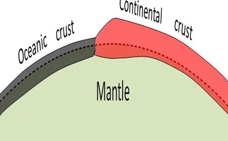
- This crust is part of the Earth's upper mantle, and the crust and mantle together make up the oceanic crust.
- Because of this, there are some unique geological features there.
- At the tops of the ridges, new basaltic lava flows are visible on the ocean floor.
- As the seafloor recedes from the area, sediments are slowly covering these lava flows.
- There is a lot more heat moving out of the rock at the crests than anywhere else on Earth.
- Along the crests of the offset ridge segments and transform faults, earthquakes happen often. Looking at earthquakes that happen at the tops of ridges shows that the marine rock is tense there.
- The age of the ocean crust is closely linked to the depths of the water above oceanic peaks.
- To be more exact, the ocean depth is equal to the square root of the crustal age.
- One theory says that the deeper layers get deeper over time because the marine crust and upper mantle get cooler as they move away from the spreading center on the bottom of an oceanic plate.
- Because this kind of tectonic plate gets about 100 km (62 miles) thick, only a small percentage of compression can predict the whole shape of an oceanic ridge.
- This means that a ridge's width is equal to twice the distance between its peak and the point where the plate has reached a steady temperature.
- The ocean depth is about 5 to 5.5 km (3.1 to 3.5 miles) after 70 million or 80 million years, when most of the cooling takes place.
- Because of cooling over time, ridges that spread more slowly, like the Mid-Atlantic Ridge, are smaller than ridges that spread more quickly, like the East Pacific Rise.
- Researchers have also found a link between the rate of global spreading and the movement of water between oceans and countries.
Mid-Oceanic Ridges Major Distribution
- In every ocean area, you can find an oceanic spreading center.
- Near the eastern edge of the Arctic Ocean is a slow-rate spreading center in the Eurasian basin.
- Along transform lines, it can be tracked south to Iceland. Iceland was formed by a hot spot that was right below a center of marine spreading.
- This ridge runs south from Iceland and doesn't have a rift valley, even though it's growing at a rate of 20 mm (0.8 inches) per year or less. This is thought to be because of the hot spot.
Atlantic Ocean
- From Iceland to the very southernmost part of the Atlantic Ocean, near 60° S latitude, the Mid-Atlantic Ridge goes.
- It used to be called a mid-ocean ridge because it goes through the Atlantic Ocean area.
- People didn't know much about the Mid-Atlantic Ridge in the 1800s.
- Matthew Fontaine Maury, a sailor in the US Navy, made a map of the Atlantic in 1855 and called it a shallow "middle ground."
- In the 1950s, American oceanographers Bruce Heezen and Maurice Ewing said it looked like a single mountain range.
- When rates are fast, the top has a high in the middle. The sides of the rifted ridges that spread slowly have rough, broken terrain, while the sides of the ridges that spread faster are much smoother.
Indian Ocean
- The ocean between Africa and Antarctica is split by the Southwest Indian Line, an ocean line that moves very slowly.
- It links the Mid-Indian and Southeast Indian mountains to the east of Madagascar.
- The Carlsberg Ridge is at the northern end of the Mid-Indian Ridge.
- As it goes north, it joins growing centers in the Red Sea and the Gulf of Aden.
- At this point, spreading is very slow, but on the Carlsberg and Mid-Indian ridges, it's getting close to medium speeds.
- Southeast Indian Ridge moves about the same speed as before.
- This ridge starts in the western Indian Ocean and goes southeast.
- It cuts the ocean in half, separating Australia and Antarctica.
- The Southwest Indian Ridge is easy to spot because of its rifted crests and rough mountain sides.
- There are not as many of these traits on the Mid-Indian Ridge as there are on the Southeast Indian Ridge. This one also clearly shows how the sea floor is moving in different directions south of Australia.
- Magnetic anomalies show that rates have varied frequently over the past 50 to 60 million years on both sides of the spreading center.
Pacific Ocean
- Going northeast, the Pacific-Antarctic Ridge meets the East Pacific Rise off the coast of South America. It starts halfway between New Zealand and Antarctica and goes down to the ocean.
- The first spreads at rates between moderate and fast.
- The East Pacific Rise goes up to the Gulf of California in the north, where it meets the transform zone of the Pacific-North American plate border.
- At this point, the East Pacific Rise is moving out to sea from Chile and Peru at a rate of at least 159 mm (6.3 inches) per year. Rates drop to about 60 mm (2.4 inches) per year at the mouth of the Gulf of California.
- Instead of a rift valley, the ridge's crest is made up of a low rise in the ground.
- The Challenger Expedition in the 1870s found the East Pacific Rise.
- The 1950s and 1960s were years when oceanographers like Heezen, Ewing, and Henry W. Menard wrote about it in its most general form. In the 1980s, Kenneth C. Macdonald, Paul J. Fox, and Peter F. Lonsdale found that the main spreading center seemed to be broken and pushed to the side by a few kilometers in several places along the East Pacific Rise.
- But the ends of the distant spreading centers overlap by a few kilometers.
- It was found that these are overlapped spreading centers, a new type of geological trait of spreading centers in the ocean.
- According to theory, breaks in the flow of magma to the crest along its length are what cause these centers. They show a basic division of the ridge on a scale of tens to hundreds of kilometers.
- A lot of smaller spreading centers split off from the bigger ones or hide behind island arcs.
- A spreading center can be found on the Fiji Plateau between the New Hebrides and the Fiji Islands in the western Pacific.
- Another one can be found in the Woodlark Basin between New Guinea and the Solomon Islands. There are a number of spreading centers and transform faults between the East Pacific Rise and South America, between 40° and 50° S latitude.
- If you look in the Scotia Sea, which is between South America and the Antarctic Peninsula, you can find a growing center.
- The Galapagos spreading center runs east to west and is between the East Pacific Rise and South America, close to the Equator.
- Three small spreading centers can be found a few hundred kilometers off the coast of the Pacific Northwest.
- Between the coasts of northern California and Oregon and Washington is the Juan de Fuca Ridge, and between the coasts of Vancouver Island and Oregon and Washington is the Explorer Ridge.
What's Your Reaction?


